

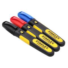
StanleyPermanent marker FatMax Colour - pack of 3 (0-47-315) Sta...
Leave clearly legible marks on wood, metal and masonry for marking out cuts and holes.

The ADS100 airborne digital sensor Leica is intended for professional use in the following contexts:
Laser and surveying instruments include laser distance meters, laser levels, rotary lasers, GNSS receivers and machine control systems, with tripods and accessories, for measuring and setting out.
Used for topographic surveying and site setting-out.
Set the instrument on a tripod or stable base, away from vibration, and let it self-level or level it manually. Before starting, check accuracy against a known reference and, outdoors, use the detector or staff to read the beam. Never look into the laser beam, and transport the instrument switched off in its case.
Designed for surveyors.
Reference standards: CE marking in accordance with the EU directives applicable to the airborne systems sector, compliance with the technical and safety standards in force, technical documentation supplied by the manufacturer Leica.
Airborne digital sensor ADS100 Leica (Leica) — Higher acquisition efficiency, increased image quality, reduced flight time and fastest processing speed Leica ADS100 SH100 and SH120 airborne digital sensor The Leica ADS100 product family continues to lead the path of airborne evolution. With its number of unique features, it is designed to meet the needs of 21st century airborne imaging with higher image quality, enhanced accuracy, improved acquisition efficiency, higher processing speed, more applications and reduced costs. Its newer variant, the SH120 with its 120mm long focal length for increased ground resolution is designed for urban mapping or high altitude data collection. In addition, the Leica ADS100 product family supports a unified aircraft installation. Significantly reduce cost of ownership and simplify operations when all aircraft components, such as Leica PAV100 high-performance, camera controller CC33 as well as operator and pilot displays, can be shared with other Leica Geosystems airborne sensors. Leica ADS100 SH100 and SH120 – Leading airborne evolution. Contact us today for a demo.
Tell us the quantities you need and the intended use: if there is a more suitable version, or an equivalent available sooner, we will let you know.
For prices and availability, request a quote from AMES Srl: we will reply with our quotation, delivery times and, where needed, an equivalent technical alternative.
| Item code | ADS100 |
|---|---|
| Type | Airborne digital sensor |
| Variants | SH100, SH120 (120 mm focal length) |
| Swath | 20,000 RGBN pixels |
| GNSS/IMU | Integrated NovAtel SPAN |
| Common components | Leica PAV100 mount, CC33 camera controller |
Everything you need in one place, from functionality to safety.
Leave clearly legible marks on wood, metal and masonry for marking out cuts and holes.
We use essential cookies to make the site work, and, only with your consent, analytics and marketing cookies to understand how it is used and to offer you relevant content. You can change your mind at any time. Read the privacy policy
For purchasing offices and MRO buyers
Search by task
Thank you! Your request has reached one of our buyers: we'll reply within 24 working hours with the quote or with any questions needed to complete it.